Truth & Goodness
War, Coal, and Conscience: When Profit Obscures Suffering
08 April 2026
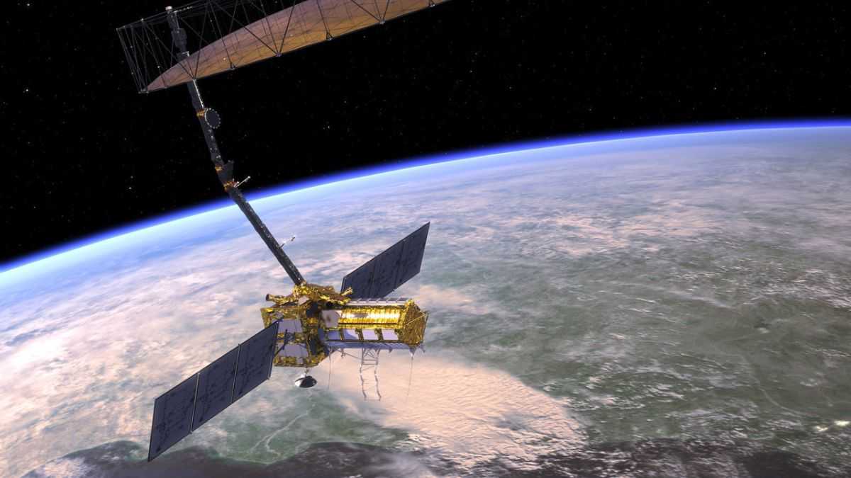
Earth has a new guardian in orbit. Called NISAR, it's a new satellite that will scan our planet from above and warn us about potential disasters. Here's what we know about the advanced technology that will protect us from hurricanes, floods, and volcanoes.
The Earth’s newest satellite is named NISAR. It’s a joint project between NASA and the Indian Space Research Organisation (ISRO). The satellite launched on July 30, and it is currently in a three-month testing phase. After that, NISAR will become fully operational and begin regularly scanning our planet.
Earth’s newest satellite will scan the planet’s surface twice every 12 days. Why twice? It has two modern radars that receive signals on two different frequency bands: L and S. This configuration provides the most comprehensive data about our planet and its surface. For example, when scanning vegetation, the L-band radar will scan taller plants like trees, while the S-band radar will provide information about lower plants like shrubs.
Analyzing plants is not NISAR’s main goal. Scientists from NASA and ISRO expect the device to deliver crucial data for other purposes.
NISAR’s key tasks include monitoring:
The data gathered will help scientists predict certain disasters in advance, which will allow for early warnings and quick evacuations. This will help reduce the number of people affected by hurricanes, storms, and floods. Furthermore, NISAR will study how deforestation, melting permafrost, and fires affect the carbon cycle.
That is not all. NISAR’s orbit allows it to scan almost the entire continent of Antarctica. Thanks to this positioning, researchers from NASA and ISRO will receive comprehensive data on the melting and movement of glaciers in the Southern Hemisphere.
Sending NISAR into orbit is the first engineering collaboration between NASA and ISRO. The Indian space agency built the satellite’s body, the S-band radar, and the rocket that launched the device. NISAR took off from a base in India on July 30. In turn, the Americans provided the L-band radar, the subsystems for data collection and transmission, and the GPS system.
The comprehensive scans of our planet will deliver data to scientists in both India and the USA. The total cost of the project is over $1.2 billion, and work on it began in the early 2010s. NISAR orbits our planet 14 times a day, at an altitude of 747 km. The mission is scheduled to last for at least three years.
You might like to read: Stunning Mars Photo: The Red Planet Looks Almost Like Earth
Read the original article: Zyskaliśmy strażnika w kosmosie. Ostrzeże nas przed katastrofą


A journalist and a graduate of Jagiellonian University. He gained experience in radio and online media. He has dozens of publications on new technologies and space exploration. He is interested in modern energy. A lover of Italian cuisine, especially pasta in every form.

Truth & Goodness
07 April 2026


Zmień tryb na ciemny